10 Best Hiking Trails in San Diego for Every Skill Level
One of the best things about San Diego is how quickly the landscape changes. You can walk above the Pacific in the morning, follow a waterfall into the backcountry after lunch, and climb through pine and oak forests before sunset.
Whether you’re taking your first trail walk or looking for a full-day challenge, there’s a route here for you. We rounded up 10 of our favorite hikes across San Diego County, organized by general difficulty, to help you find your next adventure.
Trail distances and conditions can change depending on your route, trailhead, weather, and seasonal closures. Always check the official park or land-management website before leaving home.
Beginner-Friendly Trails
1. Torrey Pines Beach Trail Loop
Distance: Approximately 2.3 miles
Location: Torrey Pines State Natural Reserve
Best for: Coastal views and a classic San Diego introduction to hiking
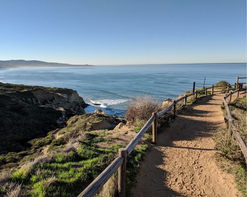
Torrey Pines is popular for a reason. This short route combines windswept Torrey pine trees, sculpted sandstone cliffs, coastal overlooks, and access to the beach below.
The Beach Trail includes stairs, uneven ground, and a climb back to the top, so it isn’t completely flat. Stay back from unstable cliff edges, check the tide before walking along the beach, and expect limited parking on busy weekends.
Check conditions at Torrey Pines State Natural Reserve
2. Lake Miramar Loop
Distance: Approximately 5 miles
Location: Scripps Ranch
Best for: Walking, running, and an easy-paced morning outside
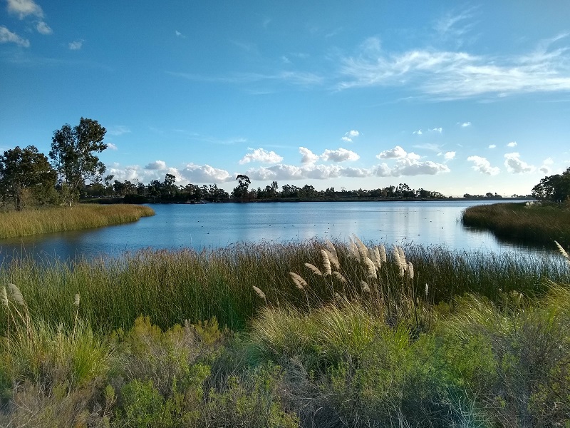
The paved route around Miramar Reservoir is a great option when you want distance without a technical trail. The relatively gentle terrain makes it approachable for newer hikers, runners, families, and anyone looking for a relaxed outdoor reset.
There are picnic areas and views across the reservoir, but shade is limited along portions of the loop. Check current operating days and access information before visiting.
Plan your visit to Miramar Reservoir
3. Los Peñasquitos Canyon to the Waterfall
Distance: Approximately 6 to 7 miles round trip, depending on the trailhead
Location: Los Peñasquitos Canyon Preserve
Best for: A longer but mostly gentle nature walk

Los Peñasquitos Canyon feels surprisingly removed from the city. Broad trails follow the creek through riparian habitat, grassland, and stands of sycamore and oak before reaching a small cascade flowing over volcanic rock.
The waterfall is more of a scenic cascade than a towering drop, and its flow varies throughout the year. Trails may close after rain because of flooding, mud, or damage, so check the preserve’s status before heading out.
Explore Los Peñasquitos Canyon Preserve
Moderate Trails
4. Cowles Mountain Trail
Distance: Approximately 3 miles round trip
Location: Mission Trails Regional Park
Best for: A quick summit workout close to the city

Cowles Mountain is one of San Diego’s most recognizable hikes. The trail climbs steadily to the highest point within the City of San Diego, where clear conditions can reveal sweeping views across the county.
The main trail is rocky, exposed, and often crowded. Start early, bring water, and stay on the designated path to help protect the surrounding habitat.
View Mission Trails maps and visitor information
5. Iron Mountain Trail
Distance: Approximately 5.5 to 6 miles round trip
Location: Poway
Best for: A steady climb with wide-open summit views
Iron Mountain offers a classic inland San Diego hiking experience: chaparral-covered hills, rocky switchbacks, and expansive views from the summit.
There is very little shade, and temperatures can climb quickly. Save this one for a cool day or an early start, carry more water than you think you’ll need, and avoid hiking during extreme heat.
6. Potato Chip Rock via the Lake Poway Trail
Distance: Approximately 7.5 miles round trip
Location: Poway
Best for: A challenging climb and San Diego’s most famous trail photo

The route from Lake Poway climbs steadily toward the summit of Mount Woodson and its instantly recognizable Potato Chip Rock formation. Along the way, hikers get broad views over the reservoir, surrounding hills, and inland San Diego County.
This route is steep, rocky, and almost entirely exposed. The photo spot may also have a line on busy days. Treat the rock formation carefully, keep a safe distance from exposed edges, and never let the photo become more important than your footing.
Review Lake Poway information before visiting
7. Cuyamaca Peak
Distance: Approximately 7 miles round trip from Paso Picacho
Location: Cuyamaca Rancho State Park
Best for: Cooler mountain air and high-elevation views

Rising to 6,512 feet, Cuyamaca Peak is the second-highest summit in San Diego County. The most direct route follows a paved fire road from Paso Picacho through recovering woodland to panoramic views of the surrounding mountains, desert, and coastline on clear days.
The sustained climb makes this a solid workout, but the route is less technical than many backcountry trails. Conditions can be significantly cooler and windier than the coast, and winter may bring snow or ice.
Plan your visit to Cuyamaca Rancho State Park
Advanced Trails
8. Cedar Creek Falls via the San Diego River Gorge Trail
Distance: Approximately 5.5 miles round trip
Location: Ramona
Best for: Experienced hikers visiting during cool weather
Permit: Required

Cedar Creek Falls drops roughly 80 feet into a pool surrounded by steep backcountry terrain. The hike begins with a long descent, which means the most demanding part - approximately 1,800 feet of climbing - comes on the return.
Do not underestimate this trail because of its mileage. It is steep, exposed, and commonly closed during high temperatures. The Forest Service recommends carrying at least three to four liters of water per person, and every visitor entering the permitted area must have a valid advance permit. Climbing, jumping, and diving from the surrounding cliffs are prohibited.
As of September 3, 2026, the trail is temporarily closed because of excessive heat. Always confirm its current status before making plans.
Check Cedar Creek Falls conditions and permit requirements
9. El Cajon Mountain Trail
Distance: Approximately 11 miles round trip
Location: El Monte County Park near Lakeside
Best for: A demanding, full-day training hike

Often called El Capitan or El Cap, El Cajon Mountain is widely considered one of San Diego County’s toughest established day hikes. Repeated climbs and descents make the return journey more difficult than the elevation profile initially suggests.
Expect steep grades, loose rock, minimal shade, and several hours of sustained effort. Start early, carry plenty of food and water, and save the route for a cool day. This is not a trail to attempt during a heat advisory.
Check current San Diego County park notices
10. Three Sisters Falls Trail
Distance: Approximately 4 miles round trip
Location: Cleveland National Forest near Descanso
Best for: Experienced hikers comfortable with steep, rugged terrain

Three Sisters Falls leads into a remote canyon containing a series of seasonal waterfalls and rocky pools. Its relatively short mileage is deceptive - the route is exposed, steep, and physically demanding, particularly on the climb back to the trailhead.
Water flow changes dramatically with the season, and wet rock around the falls can be extremely slippery. Avoid jumping or diving, carry ample water, and do not attempt the hike during extreme heat. Seasonal closures may be in effect, so confirm current Forest Service alerts before driving to the trailhead.
Check current Cleveland National Forest conditions
Before You Hit the Trail
San Diego’s climate can make a moderate hike dangerous surprisingly quickly. Before leaving home:
- Check the official trail status and weather forecast
- Avoid exposed inland hikes during high heat
- Carry enough water for the full return journey
- Tell someone where you’re going
- Download or carry a trail map
- Wear shoes suited to the terrain
- Pack out everything you bring in
- Stay on designated trails
- Leave plants, rocks, and wildlife undisturbed
Difficulty is personal. Distance, elevation, heat, terrain, and your own experience all matter, so choose the hike that fits the conditions and how you feel that day.
Find Your Way Outside
From coastal bluffs and quiet canyons to waterfalls and mountain summits, San Diego County offers an incredible amount of landscape to explore.
Start where you are, bring what you need, and take care of the places that make these adventures possible. The best hike isn’t necessarily the hardest or most photogenic one - it’s the one that leaves you feeling more connected to the world around you.